
Iceland has three large national parks that protect different parts of the country. The oldest of these national parks is þingvellir National Park.
Thingvellir National Park was established in 1928 to protect the remains of the meeting place and covers an area of approximately 23,700 hectares. The park in the southwest of the country is one of the most visited places on the entire island and was even declared a UNESCO World Heritage Site in 2004 due to its historical significance. This is because þingvellir is not only one of the few places in the world on land where you can see two continental plates moving away from each other, but it is also one of the most important places in Iceland's history. The name " þingvellir" translates as gathering fields and is due to the original use of the place.
For some years now, there has been a visitor centre at Hakid next to the viewing platform, where guests can get information about the park and the sights and buy small souvenirs. The visitor centre also offers (for a small entrance fee) the opportunity to learn more about the history and nature of the national park with the interactive exhibition "Heart of Iceland" on a 40-60 minute tour. In addition to the visitor centre, there is also a service centre where visitors can get general information about the park, maps for the hiking trails and information about sights in the region and the condition of the roads. There is also a small cafeteria where snacks and drinks are available.
Those who want to explore the national park on their own can easily do so on numerous hiking trails or on the back of an Icelandic horse. Lake Thingvallavatn also offers many places where fishing is permitted with a licence.
Tip: In summer, the national park rangers organise two free tours of the park every day. The first starts at 10:00 at Thingvallakirkja (the church) and the second at 14:00 at the visitor centre. The tours are in English and last about one hour each.
Location & Approach
The park is located about 45 minutes from Reykjavik in the southwest of the country and is a stop on the Golden Circle. The best way to reach the visitor centre by car is via the Ring Road (road 1) and road 36. The park is located at the upper end of Lake Thingvellir.
There are several paid parking areas in Thingvellir Park:
- P1 Hakid: At the visitor centre next to the viewpoint at the top of Almannagjá Gorge.
- P2 Fossplan: Two car parks near Öxaráfoss and the meeting field.
- P3 Valhöll: On the southern side of the gathering Field.
Historical importance
In 930 AD, the first general assembly, the Althing, was held in the National Park after an envoy from the clans in Iceland travelled to Norway to learn the laws and customs there and adopt them as a model for the new society. The Althing is thus one of the oldest parliamentary assemblies in the world.
After its founding, the Althing met annually on a rock formation called "Law Rock" to set aside disputes, pass laws and bring criminals to justice. These sessions continued until 1798, when Iceland became part of the Norwegian monarchy.
Over the centuries, some important political decisions took place in Thingvellir National Park:
- In 1000, the decision was made there to convert to Christianity and abandon belief in the Norse gods and paganism
- Between 1271 and 1273, the law of the Norwegian King Magnus VI was adopted in several sessions there.
- In 1944, Iceland's sovereignty was restored there, after a treaty of union with Denmark had already been signed in 1918
Geological importance
During the last ice age, the entire country was covered by a layer of ice more than 1000 metres thick. Under this ice layer, however, there was strong volcanic activity in many places, which led to volcanic eruptions melting the glacial ice in some places and forming cavities under the ice or breakthroughs. In the cavities, the lava formed palagonite mountains and long palagonite ridges.
As the temperature rose 18,000 years ago, the glacier began to melt, revealing the first evidence of Lake Thingvallavatn about 12,000 years ago. As the glacier retreated northwards, the meltwater collected in a depression, forming the lake and revealing the palagonite mountains previously hidden by the ice.
About 10,000 years ago, the glacier reached its present position and a shield volcano eruption began, forming Mount Skjaldbreiður and a shield volcano south of Mount Hrafnabjörg. As the water level in the lake rose, it sank at the same time, as the lava filled most of the lake and flattened it in this way.
About 3000 years ago, þjófahraun was formed by opening an 8 km long eruptive fissure northeast of Hrafnabjörg.
The last eruption in the Thingvellir depression took place 1000 years ago and the resulting eruptive fissure lies northeast of Mount Hengill. The lava flowed into Lake Thingvallatn and the Sandey ash crater was formed. Since this eruption, volcanic activity at Thingvellir has been dormant, but it is not a question of if, but rather when it will resume.
Sights around the National Park
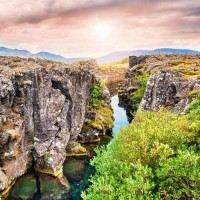
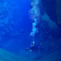 Silfra Rift:
Silfra is a submerged canyon within Thingvellir National Park, formed by the drifting apart of the North American and Eurasian continental plates. The crevice is one of the best places in the world for divers and snorkellers. The clear glacier water has temperatures around freezing point and impresses with a visibility of up to 100 metres.
Davíðsgja Rift:
Besides the Silfra Rift, there is another place in Lake Thingvallavatn that is ideal for diving: the Davidsgja Rift. The crevice is located in the north-east of the lake and can only be reached by swimming. It is not as well known as the Silfra rift, but is especially popular with local divers. The water is usually warmer than in the Silfra rift, but visibility is more dependent on the weather.
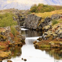
Alamannagjá - The Allmans Gorge:
The gorge is an impressive geological formation formed by the drifting apart of the North American and Eurasian tectonic plates. There is a viewing platform at the edge of the gorge, from which a staircase leads to the hiking trail through the gorge.
Lögberg:
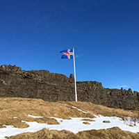
Logberg is also known as the "Law Rock" because it was here that the laws of the Commonwealth were promulgated by the Law Speaker from 930 - 1262. In addition to the proclamation of the laws, anyone could come forward here and express their opinion, report on events and make speeches. The exact location of Lögberg cannot yet be confirmed but there are two rocks that are considered likely based on documents and paintings. The probable rock is marked with a flag so that visitors can find it.
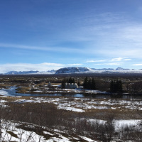
Lake Thingvallavatn:
Lake Thingvallavatn is the largest lake in Iceland and is partly located in the National Park. It offers stunning scenery and the opportunity to boat across the lake and fish (with permission).
Öxaráfoss waterfall:
Oxarafoss is located in Allmannagjá - the Allmans Gorge and springs from the river Öxará. It is believed that the waterfall was artificially diverted to channel the water near the meeting place. At the foot of the waterfall it is wonderful to have a picnic and admire the picturesque surroundings.
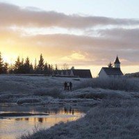
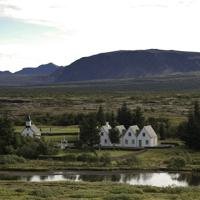
Þingvallakirkja:
The current Thingvallakirkja was built in 1859, but legend has it that there has been a church on the same spot since 1017. The church is normally closed except when a staff member is on site. This is usually at 10:00, when the free guided tour by the park rangers starts at the church.
Camping
In the National Park, the two campsites at Leirar and Vatnskot invite you to stay. In summer, the two sites are open from June to September, and in winter you can camp at the Leirar site near the service centre. The toilets and washrooms are open all year round, but the showers are closed from 1 December to 1 April. There are more toilets at the Silfa rift. In summer, the campsites are monitored by park rangers, sometimes overnight, to ensure peace and order.
Nearby
Due to its location on the Golden Circle, there are also a number of other spectacular sights in the vicinity of Thingvellir National Park. These include the Gullfoss waterfall, the Geysir and geothermal area, the city Selfoss, and the historic town of Skálholt.