
In June 2001, the third and youngest national park in Iceland was established in West Iceland - Snaefellsjökull National Park.
Snaefellsjökull National Park was established with the aim of protecting the unique nature of the area and important historical remains from ancient times. The national park also aims to make travelling in the region possible and accessible to people. It is the only Icelandic national park that stretches from the top of a mountain to the coast. The national park is named after its main attraction: the Snaefellsjökull glacier.
There are two visitor centres where guests can get information about the national park from May to September. The centre in Malarrif has an interesting exhibition about nature and fishing relics. The Hellissand visitor centre was reopened in 2023 and, in addition to information, there is also an exhibition hall and a small restaurant where visitors can eat.
A map shows which hikes can be undertaken in the national park. There is also a wide choice of varied excursions to the national park, such as a horseback riding tour lasting several days or a hike across the Snaefellsjökull glacier.
Location & Approach
The national park is located at the tip of the Snaefellsnes peninsula in the west of Iceland and covers approximately 170 km². The southern border of the park runs to Háahraun in the Dagverðará region and the northern border of the park extends to Gufuskálat.
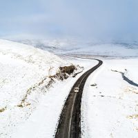
Road No. 574 runs once through the national park and the neighbouring nature reserves. It can be driven from both the south and the north. It takes about 3 hours to drive the 124 miles from the capital Reykjavik.
Historical importance
Archaeological findings indicate that the area where the national park is located today was already inhabited 1100 years ago. For example, Forni Saxhóll Farm, Berutóftir and Írskubúðir date from this time. Near Gufuskálar there are several dome-like buildings of unknown origin, estimated to be between 500 and 700 years old. This makes them among the oldest known fishing relics in all of Scandinavia.
One of the main reasons for the settlement of the area is definitely the location by the sea and the resulting opportunities for fishing. In the 13th century, the population in the area around the glacier grew due to the flourishing fishing. In the 18th century, it was even one of the most densely populated areas in all of Iceland. In the 19th century, fishing numbers declined due to technological advances in the industry.
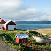
All the villages around the national park, including Hellisandur, Rif and Ólafsvík, were all fishing centres and today these communities still have thriving harbours and a vibrant community.
Geological importance
The flatland on the coast of the national park is mostly covered by lava that has flowed from the glacier or nearby craters. It is overgrown with moss, but there are also some sheltered hollows where a variety of flowering plants grow. The eponymous glacier towers majestically over the park and all around you can clearly see the results of past volcanic activity. On the north side of the park is the Eysteinsdalur valley surrounded by steep mountains.
On the Snaefellsnes Peninsula, geological formations from almost all eras of Iceland's past can be found. In the Snaefellsjokull system of volcanoes, individual eruptions can be traced from both the Ice Age and more recent days. The more conspicuous formations were mostly formed in geologically modern times, i.e. since the last ice age in 1890. North of the glacier, around Bárdarkista, are some hills made of volcanic palagonite tuff and eruptions formed under the glacier or below the sea surface.
The lava that characterises the landscape of the peninsula can be divided into two different types: rough, fissured lava and smooth, pulpy lava. Most of the lava comes from eruptions of the volcano under the glacier, the summit crater or from secondary craters on the flanks of the mountain. In addition to the diverse lava formations, there are also many lava caves in the region, which, however, should only be entered with an experienced guide on the recommendation of the national park management. Other small volcanic craters surrounded by lava in the area are Purkhólar, Hólahólar, Saxhólar and Öndverdarneshólar.
Flora & Fauna
Despite the porous soil in the national park, there is a diverse flora. Along the coast, many plants and colourful algae grow in crystal clear pools, and the lava is also covered with a thick layer of moss in places. In sheltered areas you can also find flowering plants and, in late summer, numerous ripe berry species such as blueberries and bilberries.
Due to the long coastline, there are several species of birds that live and breed in the national park. The most common bird species are the guillemot, the razorbill, the fulmar and the shag. You can also find nesting sites of different species of gulls on almost every rock. In the interior of the peninsula, golden plovers, whimbrels, meadow pipits, grey buntings and wheatears can be observed.
In addition to the various bird species, foxes, minks and field mice also inhabit the region. Seals, grey seals and also small whale species such as killer whales, minke whales and porpoises can also be seen on the coast.
Sights around the National Park
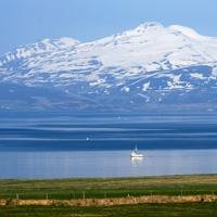
Snaefellsjökull glacier:
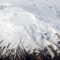
The glacier is undisputedly the main attraction of the national park and sits enthroned in the middle. It is often referred to as the "king of Icelandic mountains", because with its 1581-yards height it was long considered the highest mountain in the country. The mountain is an active stratovolcano, formed from many eruptions over the last 800,000 years. The 218-yards-deep crater is filled with ice and surrounded by snow-covered cliffs. In recent years, the glacier has shrunk to a size of 11 square kilometres. The last eruption occurred about 1,800 years ago, forming the Háahraun lava field, among other things.
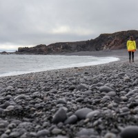 Djúpalónssandur:
The beautiful black pebble beach is one of the few places where you can walk from the yards-high dark cliffs directly to the sea. The pebbles are popularly called the "pearls of Djúpalón". A series of mysterious rocks rise out of the sea and are the subject of many legends. The remains of a shipwreck that ran aground in 1948 also lie on the beach, in keeping with the beach's past. For many years ago, Djupalonssandur and the rest of Dritvik Bay was an important fishing station. At its peak, up to 60 ships set off from there on their voyages and around 400 people lived in the area. The ruins of the old buildings can still be seen and admired today. If you walk along the beach for about 1000 yards, you will come to a series of stones: the so-called strength test stones. With these stones of different weights, applicants of the fishing boats had to test their strength. Applicants who could lift the heaviest stone, the "Fullsterkur" (full-strength stone) weighing 24 Stone, were assured a place in the boat. The 15 Stone "Hálfsterkur" (half-strength), the 8,5 Stone "Hálfdrættingur" (custom) and 3,6 Stone "Amlódi" (weakling). The stones had to be thrown on a rock to pass the test. This rock still stands on site today, but is much lower than it used to be due to wear and tear.
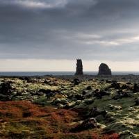
Lóndrangar:
In the southern part of the national park, you can marvel at the two rock formations that jut out of the sea in front of the cliff. The Londrangar are the remains of a volcanic crater and were probably formed during an undersea eruption. Nowadays, due to abrasion by the ocean, only two pillars, 82 yards and 66 yards high, can be seen, providing a place for many seabirds to breed and nest. According to legend, the rocks and fields around them are inhabited by elves who use the pillars as a church. For this reason, the fields on the cliff have never been cultivated by local farmers. Visitors can easily walk from Malarrif across the moss-covered fields to the end of the cliffs to explore.
Vatnshellir:
Vatsnahellir is one of the oldest lava tunnels in all of Iceland. The tunnel was formed about 8000 years ago during a volcanic eruption and was opened to visitors in 2009. Today, a spiral staircase leads inside the tunnel, making it easier to enter. However, it is not permitted to enter the cave without an experienced guide, which is why there are many tours offering a visit to the cave in summer. Although the entrance to the tunnel is quite easy, the uneven and usually poorly lit floor makes it difficult to visit.
Saxholl Crater:
The crater is located right on the side of the road 574. A metal staircase leads to the top of the crater and reveals a fantastic view over the huge Neshraun lava flows and the surrounding area
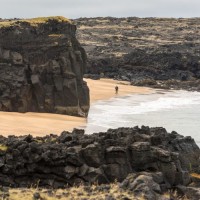
Skardsvík:
The golden sandy beach of Skardsvik is a found change from the many black lava beaches in Iceland. The water at the beach can have a bright turquoise colour and practically invites you to go into the water. But you should be careful, because the current and waves on the beach are very strong and can be dangerous.
Malarrif Lighthouse:
The 26-yard high lighthouse on the cliffs near Londranger was built in 1946 and stands right by the visitor centre at the southernmost point of the peninsula. The lighthouse that stands today replaced the one first built in 1916 and has been guiding ships around the lower tip of the peninsula ever since. Unfortunately, the lighthouse cannot be visited.
Nearby
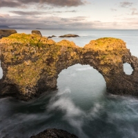
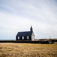
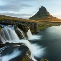
In the immediate vicinity of the national park, there are several villages in addition to the other nature reserves of Búðahraun, Arnarstapi, Hellnar and the natural monument of Bárðarlaug. Arnarstapi has 150 inhabitants and is still a lively fishing village. The cliff where the village is located is home to many seabirds and has many beautiful hiking trails where you can explore the surrounding nature. Hellnar is situated in a picturesque bay at the foot of the glacier, making it an ideal stopover before a glacier hike or simply to admire unique rock formations of Gatklettur. Another nearby sight is the black church of Buðir - Buðakirkja. The church is one of the oldest wooden churches in the country and stands in what is now an almost abandoned village. It lies on the edge of an impressive old lava field and is definitely worth a visit. Not to be forgotten is the famous Kirkjufell mountain and its waterfall Kirkjufellfoss, which can be found near Grundafjördur. The mountain is not considered the most beautiful mountain in Iceland for nothing and is considered one of the most photogenic places in the country.
A wide range of excursions to Snaefellsjokull National Park can be booked directly with us - just contact us! For more ideas, take a look at our selection of excursions. Find inspiration for your next round trip to Iceland in our travel overview.